Created 28-Jun-20
12 photos
David, Clayton and I headed to Cabin Ridge (Twin Peaks) today, in a remote location by the Oldman River, just east of the Beehive Natural Area.
We took an adventurous (i.e. wrong) line through matchstick forest and steep gullies, across streams and through meadows. Although not the direct route, this was very scenic and still mostly enjoyable.
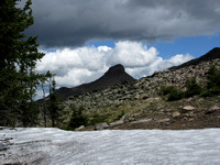
Once out of the trees, we finally saw our distant objective of North Twin Peak. First, we tagged South Twin Peak - because why not, when we made the long drive (70 km of gravel road each way) anyway?
Thunder began to roll and we were briefly pelted with hail here. No lightning flashed though, and we discussed our next move. We would progress toward the north summit unless lightning started or we heard our metal poles buzz. Thankfully, neither happened and we summited North Twin Peak in grey clouds before descending back to the ridge for an extended lunch.
On our egress, we found a lovely trail (i.e. the right way), and enjoyed our hike back to the trailhead.
Category:
Subcategory:
Subcategory Detail:
Keywords: