Created 4-Sep-13
14 photos
I enjoyed fine weather yet again on this trip to Commonwealth Peak. The bog crossing was not bad at all, and I didn't even need to change out of my boots...perhaps the water was lower than usual. After reaching the col, the scramble becomes more interesting as you must follow a series of scree or rubble slopes up to a hidden gully on the final section. The summit was very scenic, but I found it too small to relax on, and returned to the col for lunch.
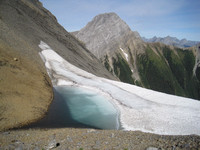
After descending to valley bottom, I extended the day with a brief foray south - toward the Robertson Glacier, in an area I've winter camped before. Extensive signs of the June flooding were evident here in the gravel and boulder-strewn forest floor, the 1 meter high cutbanks now looking like gravel shelves, and the large amount of downed wood.
This is an area I would like to return to in the near future and explore higher up the valley toward the toe of the Robertson Glacier.
Category:
Subcategory:
Subcategory Detail:
Keywords: